The Marshall Fire
“For a successful technology reality must take precedence over public relations, for nature cannot be fooled.” The early after-action reporting following the catastrophic 2021 Marshall Fire forcibly brought to mind this quote from Richard Feynman’s testimony after the 1986 Challenger space shuttle disaster. With all the 21st century technology supposedly available to guide the firefighting effort, the fire won hands down. It rendered some 1500 people homeless on the cusp of the 2022 new year, bringing into clear focus how one of the richest areas of the wealthiest country in the world has failed to respond to the reality of its location.
Not 30 days after this huge fire disaster in Boulder County, the Boulder City Council at their annual retreat declared planning for fire or flood mitigation the LOWEST priority for their five-year planning efforts. Had the jet stream feeding the awful events of December 30, 2021, moved just 15 degrees, the city of Boulder would have been completely destroyed, with a death toll in the thousands, and all the social activism priorities the Council put above fire mitigation rendered irrelevant. One would think that having been hit with two $1B disasters (one a flood, one a fire) in 10 years, governance would pay more attention to natural hazard risk mitigation, especially given their avowed concern about climate change, but it would seem that rhetoric supersedes prudent planning.
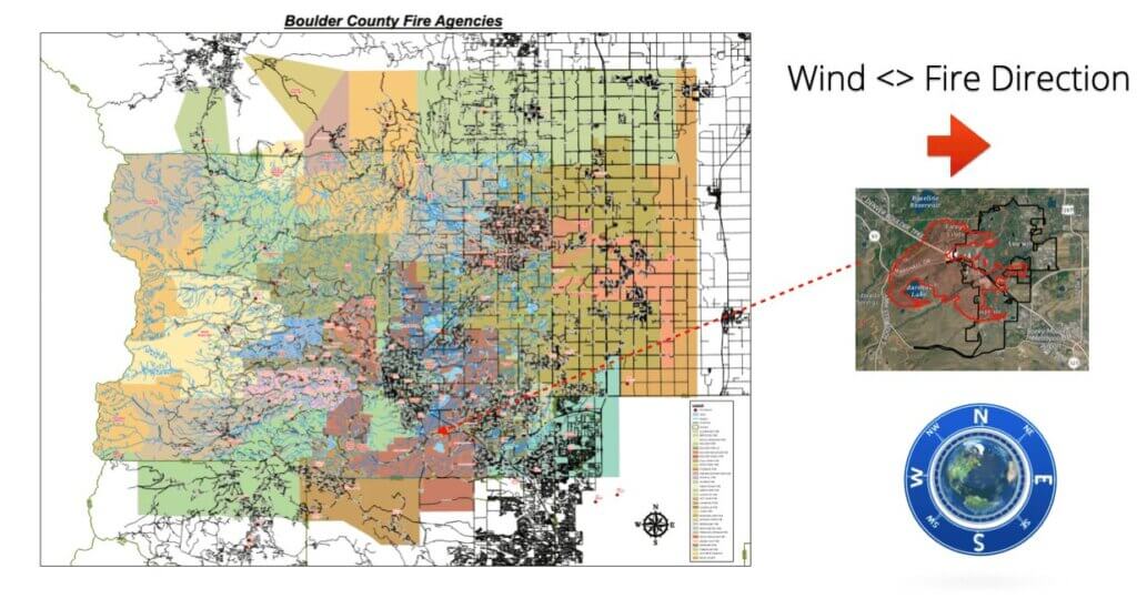
Boulder County encompasses some 720 sq miles / 1900 sq km of terrain ranging from mountainous to foothills to flat, with corresponding variations in temperature, ground moisture, snow cover, etc., as well as widely varying population densities. The county is served by 30 different fire districts, 10 cities/towns, 6 adjacent counties, and the City of Denver close by. This adds up to nearly 100 possible responding agencies, which numerically sounds good. But, as we saw with Marshall, all that availability is ineffective without prudent resource coordination and planning, including joint operations rehearsals. Systemic failures in the design, management, and funding of fire districts all contributed to the magnitude of the Marshall disaster.
Let’s start with the most fundamental question: are fire districts designed for responsiveness, meaning if a fire happens “here,” is the response directed to mitigating that specific fire? The answer to this is a resounding “NO.” The 30 fire districts in and immediately surrounding Boulder County are all designated by taxation boundaries. They may have overlapping and duplicated response areas, but a quick geospatial analysis shows many coverage gaps also occur as a result of setting boundaries that are not based on the reality of the response available. Someone may be taxed by multiple fire districts, but still have no real response availability.
All the mapping technology in use to support local decision-making around emergency response is flat world, N <> S oriented. Reality-based hazard response would build on the region’s long experience of catastrophic events that move W <> E. After action analysis of the Marshall fire shows that the wind accelerated the fire down the lowest terrain, along paths formed by stream and creek beds that became fire highways. On a flat world map, this looks like random activity, rather than the fire following the contours of the terrain. But instead of terrain- and weather-focused fire response planning, we see a strategy oriented around arbitrary taxation district boundaries that (as we saw with the Marshall Fire) actually inhibits efficacious response.
Management of fire districts is ultimately the responsibility of the governing county commissioners, volunteer boards, and city councils. They fund and regulate the emergency response entities (sheriff’s office, police department, fire department, etc.). The fire district ratings that govern how insurance companies view risk vary accordingly. I have written before about how risk reinsurance companies mine country-specific data, worldwide satellite imagery,and historic loss event data to diagnose, classify, and manage risk. They use technology to obtain the best understanding they can of reality. The further divorced from reality the focus of local governance is, the higher the risk classification of the locality.
The state of Colorado has no Fire Marshal (not a pun) to oversee and ensure coordination of the various counties and their fire districts and departments, and, as exemplified by the tax-based instead of response-based focus, this means duplication of efforts and resources, and therefore decreased efficiency of service. All told, probably over 80 cents on the dollar are spent ineffectively. For Colorado, this adds up to billions (not millions) of dollars in waste, before the economic cost of the damage from a catastrophic event is even calculated.
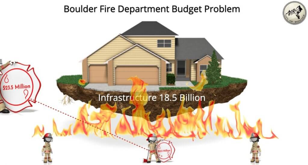
As is typical in the U.S., both the infrastructure and everything above it is severely undervalued, and this in turn pummels fire department effectiveness. Let’s take the City of Boulder as an example: the value of its infrastructure (everything that supports the operation and function of the city—roads and sidewalks, water and sewage, paved trails, etc.) is publicly estimated by the city at $2.5B. Its true value is more like $18B. City management and political leadership lowball the value to keep property taxes low for political purposes. This means that funding for all the departments that are supposed to provide the support services that prevent the city’s total collapse is also lowballed: Fire – Rescue, Police, Public Works, Housing & Human Services, Planning and Development, just to name a few.
Fire has no respect for time and is a 365-7-24 response operation. It’s interesting (!) to see how thin budgets are for the different emergency response departments that are called on to deliver full around- the-clock operations. If you stretch your manpower to its limit in an environment prone to natural catastrophe then the results show quickly in crew health, safety, and psychological stress. Looking at the raw numbers, it would appear the breaking point for crews responding to a multi-agency fire response action is around 48-72 hours. Beyond that, human endurance begins to fail and performance degradation accelerates.

All wildfires have catastrophic potential, which increases when buildings are allowed to encroach on fire-prone areas of combustible vegetation. To prevent or mitigate the scope of catastrophe, you have literally minutes to respond at the origin and get ahead of the problem with firebreaks and response planning, both building on a known mitigation strategy. It seems apparent from the events of December 30, 2021, that the region does not have a coherent, comprehensive response or mitigation strategy.
Oversight by management and dispatch relies on those static N <> S oriented flat-world PDF documents, with no links to real-time situational or weather reporting. The communications systems of first responder teams in the response area use about 97 different frequencies through an assortment of digital, analog, and dual-band radio equipment. Each technical team jealously guards the turf of their own small progress towards modernization, creating an inertial drag that shuts down any progress toward regional harmonization and interconnection. No satellite imagery (visual / LiDAR / infrared / thermal) was available to inform the firefighting, despite those resources being readily available to research institutes within Boulder. Moving from 20th century inert, sequestered technology to 21st century interactive, interconnected technology seems like simply too great a challenge to already stretched budgets and inter-district turf battles.
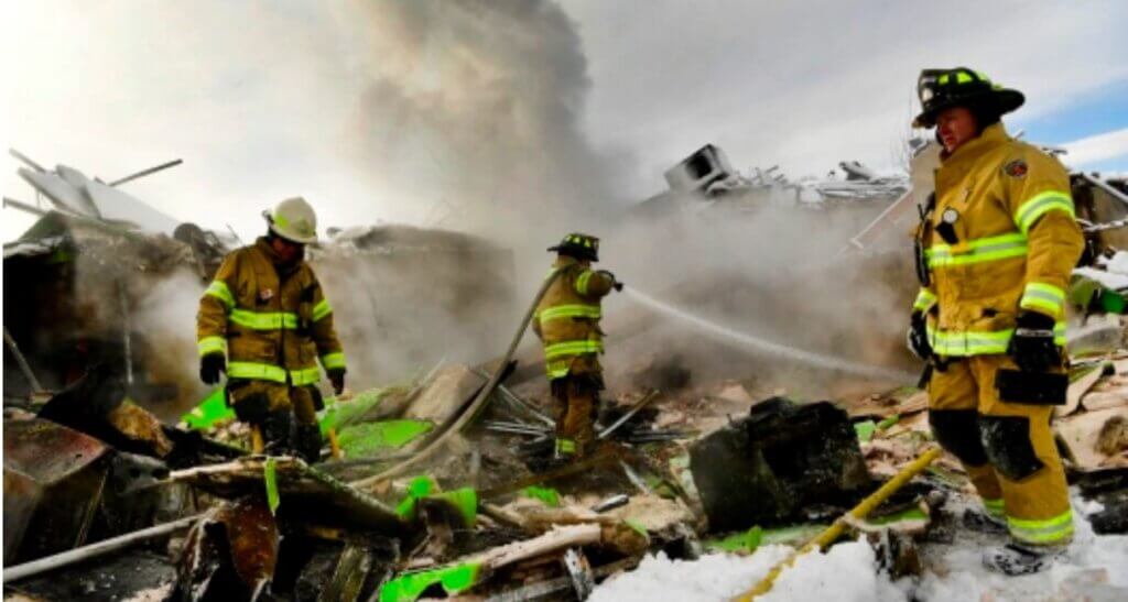
The Marshall Fire was not identified as a major event until some 15 minutes after the first call, one of over 120 received that day. All those calls had to be triaged, and by the time it became clear that Marshall was the most critical, the fire was out of control. Moved by the wind, the fire went from manageable to uncontrolled inferno in less than 30 minutes. Visibility on the ground went from bare minimum to none within a few minutes of the arrival of the first crew. The high winds meant that all large air tankers that would normally be available for fast response were grounded. The entire trajectory from the presumed starting point at Marshall Rd. to complete devastation in Louisville and Superior was 107 minutes, and by then it was game over: the stand down (“let it burn”) order was issued at 12:47 pm.
Every morning as the region’s Fire Chiefs Calderazzo (Boulder City), Willson (Louisville), Beebe (Mountain View), and Trevithick (Hygiene) and the Boulder County Fire Manager (McKinney) start their day, they refresh their situational awareness by relying on their mental maps, their experience, and their own senses. Situational awareness is a skill mostly associated with battlefield survival. It means answering the questions: “Where am I? What is the enemy doing? What resources do I have? What are the immediate impacts of terrain and weather to help or hinder my objective? What technical aids do I have to oversee all this?”

The U.S. Forest Service and U.S. Navy both provide good examples of how to build situational awareness. Both understand that human visual situational awareness directs digital; technical resources are important and useful, but no matter how many you have, the optimal response comes from humans working as a team to apply the data to real situations. The Forest Service fire response teams are directed by observers in towers placed in a pre-planned geospatial response area, and similarly the officer on the bridge of any ship directs the activities of sailors. Experience has shown us again and again that no other design comes close to optimizing human response in a crisis, but here we are in the 21st century pretending that fire identification is best done through telephone notification to a bunker that is blind to the passing of time.
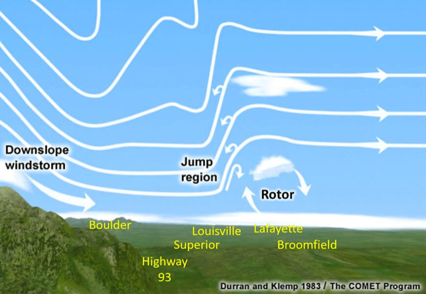
The morning of December 30th, the enemy was the weather, with unpredictable 100+ mph winter winds and a shifting jet stream giving rise to a deadly combination in which a downslope windstorm created a jump region with a rotor effect directly over the impacted area. The resources were the firefighters and equipment in each chief’s command, with the potential of support from the other 30 regional fire districts. The 30 districts had never held a joint disaster coordination exercise or simulation.
Mimicking the U.S. Forest Service and U.S. Navy approach, spotters or bridge officers on any peak of the Flatirons could have spotted the situation way before the struggling ground crews. Look-down satellite support (that did not exist) should be fed through the spotters who can immediately comprehend how the data relates to on-the-ground reality. Watchtowers and bridge crews also have multiple means of communication, including laser communications (developed at the Department of Commerce Boulder Labs in 1970s) that could be used to route and reroute fire units to match a pre-planned response pattern based on table-top scenario exercises.
This also has a spillover into human evacuation, which mostly appears to be hit or miss, especially in response to the typical speed of a wildfire like Marshall. It would appear that most evacuation plans fail due to the fact that government oversight seems to consider its job done once the evacuation warning has been sent. Then it’s up to someone else to figure out whether the warning reached the intended population and whether the evacuation routes worked (mostly they did not).
Fire naturally sends a degree of panic into any community, and sadly the media adds to this as it tries to attract eyeballs, which means the threatened recipient of the warnings now moves into a state of confusion. As we saw with a recent evacuation due to the NCAR fire, a wide shotgun warning is sent mostly over cellular networks (which has its own problems) and then 15 minutes later all evacuation routes are backed up to a complete standstill.
Fire departments need to know what type of fire they are being called out to fight so they can know which units with what type of equipment to dispatch to a major event. Do they need to carry water and bring in bulldozers to scrape firebreaks? Or is it an urban fire with available hydrants and good water pressure? Are there hazardous materials or other chemicals that require fire suppressants other than water, or perhaps cannot be extinguished but merely contained? Response strategies cannot be devised in the moment but must be planned and rehearsed collaboratively in advance. All subsequent decisions should flow from that.
The response exercise of joint operations (which never occurred) should have immediately designated (as pre-planned) Boulder Fire-Rescue (the largest directly affected department with the most resources) as the incident commander. The specific situation should have been planned for in a table-top exercise with all regional fire departments participating. In the wake of the scope of the disaster, it comes as no surprise to hear that no multi-district joint planning exercises had ever been envisioned or planned, nor had any major multi-jurisdictional mitigation efforts been undertaken.
The Marshall Fire combined grass and structural fuel sources, and the urban fire engulfed two of the three water plants supplying the hydrants. The electrical substations powering the pressure pumps were shut down, either as a result of, or in order to not add energy to, the fire. At the same time, water was pouring out unchecked from water mains under buildings that had burned. The water pressure dropped dangerously—which meant the original containment strategy that relied on high pressure hydrants failed. Fast response high impact resources such as aerial tankers could not operate in the 100+ mph wind conditions that drove the fire. If the response plan depended on these, a predefined Plan B was needed.
The first-on-scene designation for the Marshall Fire instead went to one of the smallest of the affected districts. It was categorized as an urban fire in an area well-provided with infrastructure, so they brought no tanker trucks. Instead of being able to immediately overwhelm the fire, they found themselves playing catch-up from the start, and eventually everyone lost. This was not a surprise to anyone knowledgeable of the industry: districts structured around response scenarios and mitigation are often 90% or more effective; districts designed based only on taxation boundaries are seldom better than 20% effective. Insurers know this, and that’s why rates are so high in this area, even before the fire. Imagine what they will be after the losses have been fully calculated!
The importance of mitigation cannot be understated. Without mitigation, all the responders are facing a complete unknown. Every day, the fire chiefs know that the puzzle they face that day will involve weather, fuels, and topography. There are no natural aquifers or underground water resources in this region; what water does not come from storms or snow melt (i.e., uncontrollable and unpredictable) must be piped from the Western Slope. This also affects how water is stored and captured and fed to the fire hydrants and how the hydrant systems are designed to maximize pressure in the event of a disaster (or not, as it proved) and how power is supplied to these pumps and what happens when that power source fails.
Mitigation is more than just sending out advisors to inform people of fire dangers. It is an aggressive undertaking by both fire departments and utilities to reduce fuel availability for any fire event, to understand and map all obvious terrain fire paths, to plan for firebreaks (perhaps create them in advance), and to ensure that resources (like water) are available. It’s making sure that all electrical utilities have cleared the area under transmission and distribution lines so that any line arcing or spark arrester malfunctions do not cause fires. It’s making sure that full fuel mitigation is carried out on all roads and highways, as well as on flood channels when they are dry. It’s making sure that all fire departments have a clear map of all facilities that contain hazardous materials, including lithium batteries. Last but not least, it means dedicated budget lines and manpower focused on mitigation, not just adding mitigation to a long list of unfunded and understaffed “nice to have.” It means that if an entity such as Xcel (who have not carried out mitigation on their rights of way for over 10 years) fails to do its part, it is directed into compliance in any way needed.
Mitigation is not a flat world map of intent; it’s an actual process that done properly takes 20-30% of any fire department’s budget. Adequate investment in mitigation makes any response action more effective and successful. There seems to be widespread lack of understanding at the political level that investing in mitigation saves lives and money when a catastrophic event occurs. Without mitigation, as we saw with Marshall, reaction becomes much more difficult and less effective.
As we move into greater utilization of electric vehicles and solar panels, we also create a very different risk level. Solar panel and electric vehicle fires burn at unimaginable heat levels and cannot be extinguished by water. Adequate funds must be invested in fire departments for planning and prevention to ensure the risk of these very different fuel types can be appropriately contained. Mitigation here means bringing the fire department to the table early in the planning and development process so that the risks associated with different types of building materials, utility provisioning, and siting locations can be understood, and ideally mitigated by appropriate design decisions prior to permitting. If these strictures are ignored by towns, cities, and counties the risk industry will simply transfer the fiscal burden to the building owners, which in turn brings a different kind of political backlash.
Fortunately for our brave front line heroes, the obfuscation of politics will not win this race. The major risk insurance companies have noted the impacts of poor deployment and lack of support or even prioritization for emergency services, and will respond in kind with steep increases in the cost of coverage, which will in turn focus the public mind on how this became such a failure in the first place, as they thought their taxes had paid for top-notch protection. Nor does it help when the public discovers that five times more money has gone into academic research on fire and flood prevention than has been channeled to the people doing the actual work.
The same policy wonks that fatally designed fire districts around taxes and not response now realize their error (maybe). But instead of correcting the problem, they are adding liability walls to the mix, strengthening the laws that limit by fiat the amount a jurisdiction can pay to citizens it has harmed. Liability walls are designed to deliberately contain the amount of money a city or county must pay to redress its own negligence, regardless of the extent of the damage. Liability walls simply pass the fiscal cost of negligence (such as the cost of the Marshall fire) onto the taxpayers and the victims of the disasters that were caused or exacerbated by that negligence: the risk companies raise their coverage rates to protect their own solvency.
Those consequences will not be mitigated by assigning responsibility for investigating and delivering the after action report on what worked and what did not to the organization that would be most politically embarrassed by the results rather than requesting a review by a verified independent agency or third party. This all but guarantees an after action report that functions as yet another liability wall. It’s ironic that much of Google Earth and its offshoot multi-dimensional terrain mapping and modeling that can incorporate fire prevention and hazards identification systems was developed right here in Boulder, but though use of that Boulder-developed technology has spread worldwide, its use in the county and city of its creation remains sparse.
In short, to face our future and allow the front line teams to succeed we all need to understand that a very different focus of time and money will be required. Much more attention needs to be paid to the heroes in uniform who put their lives on the line every day and pay the cost when systems fail, and less credence allowed to the oversight bureaucrats who focus on making the numbers look good on paper.
For every dollar spent on pre-planned mitigation and prevention, you can expect to reduce incident damage by twenty dollars. When, as with Marshall, those damages run into the multi- million dollars, it’s a point worth noting when the next reduction in fire department budgets is proposed.
Part 2 to follow: Part 2 will look at how better communications and communication technologies could mitigate many of the problems identified in this article. “Nature cannot be fooled” could have been the motto of DJ Atkinson, a remarkable communications research scientist with a special gift for connecting research to reality. In the public safety communications research program at the NTIA / ITS labs in Boulder, DJ clearly understood that no technology could be judged effective unless it had been rigorously tested in the field. As a result, all of his telecommunications science research was planned and executed in collaboration with the people who were actually using the technology under test. His mantra was “this is great in theory; let’s see how it works in the real world.”
Pete is a frequent speaker, lecturer and writer on best practices and the pursuit of excellence and how they work in the real world. He has been a Board Member of the Natural Hazard Mitigation Association, a Member of the American Society for Quality and the American Society of Civil Engineers, and an Advisor Member Guru of Engineers Without Borders.